Geographical zone
Latitude-based climate zones dividing Earth's surface.

SurinameCentral · CC BY-SA 4.0
Geographical zones are divisions of Earth's surface based on latitude, primarily defined by the major circles of latitude. These zones—Torrid, Temperate, and Frigid—relate to climate and were first hypothesized by Pythagoras or his followers, later modified by Aristotle. The concept remains foundational in understanding global climate patterns.
- first_hypothesized_by
- Pythagoras or his followers
Lore & Background
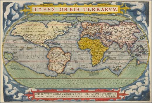
The concept of a geographical zone was first hypothesized by Pythagoras or his followers and lastingly modified by Aristotle. Both philosophers theorized the Earth divided into three types of climatic zones based on their distance from the equator. Like Parmenides, thinking that the area near the equator was too hot for habitation, Aristotle described the region around the equator as the 'Torrid Zone,' giving approximate latitudinal limits. Both philosophers reasoned the region from the Arctic Circle to the pole to be permanently frozen, calling it the 'Frigid Zone.' The only area believed to be habitable was the northern 'Temperate Zone' (Aristotle explicitly believed the southern one was uninhabitable), lying between the 'Frigid Zones' and the 'Torrid Zone.' However, humans have inhabited almost all climates on Earth, including inside the Arctic Circle.
Reader's Guide
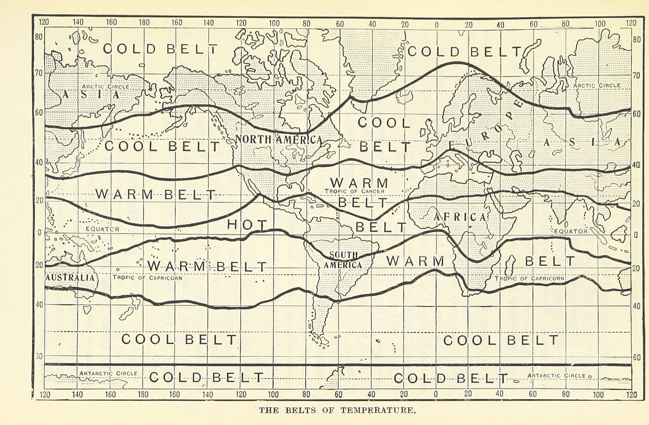
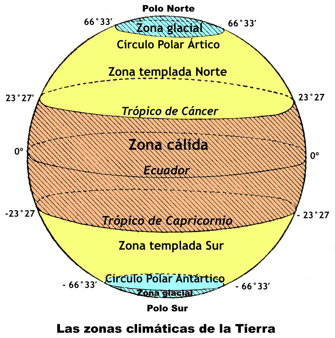
The five main latitude regions of Earth's surface comprise geographical zones, divided by the major circles of latitude. The differences between them relate to climate. The Torrid Zone, between the Tropic of Cancer and the Tropic of Capricorn, covers 39.78% of Earth's surface and includes regions such as southern Mexico, Central America, the Caribbean, northern South America, much of Africa, southern Middle East, southern Indian subcontinent, most of Southeast Asia, northern Australia, and parts of Oceania. The North Temperate Zone covers 25.99% of Earth's surface, including North America, Europe, North Africa, Northern Asia, East Asia, and northern Middle East. The South Temperate Zone also covers 25.99%, including Southern Australia, New Zealand, southern South America, and Southern Africa. The North Frigid Zone covers 4.12% and includes Alaska, northern Canada, Greenland, Norway, Finland, Sweden, and Russia. The South Frigid Zone covers 4.12% and includes only Antarctica. As knowledge of Earth's geography improved, a second 'Temperate Zone' was discovered south of the equator, and a second 'Frigid Zone' was discovered around the Antarctic. Although Aristotle's map was oversimplified, the general idea was correct. Today, the most commonly used climate map is the Köppen climate classification, developed by Wladimir Köppen, which divides the world into five major climate regions.
Did You Know?
- The Torrid Zone covers approximately 40% of Earth's surface, the largest of the five zones (though exact percentages vary by definition).
- The North and South Temperate Zones each cover about 25.99% of Earth's surface (though exact percentages vary by definition).
- The North and South Frigid Zones each cover about 4.01% of Earth's surface (though exact percentages vary by definition).
- The concept of geographical zones was first hypothesized by Pythagoras or his followers and lastingly modified by Aristotle.
Transcontinental Scale and Global Position
Russia stands as the largest nation on Earth, spanning more than 17 million square kilometers of territory—roughly one-eighth of all inhabited land on the planet. Its footprint stretches across both Europe and Asia, covering the northernmost reaches of the Eurasian landmass from latitude 41° north to 82° north and longitude 19° east to 169° west. The country's sheer magnitude is difficult to grasp: it exceeds the combined area of three continents and approximates the surface of Pluto. Eleven time zones fall within its borders, and it shares frontiers with sixteen sovereign neighbors, more than any other state. Russia also commands the world's fourth-longest coastline at nearly 38,000 kilometers, and alongside Canada and the United States, it is one of only three nations touching three separate oceans. This extraordinary geographic position gives it connections to over thirteen marginal seas and the largest expanse of forested land of any country on the planet.
Boundaries, Coastlines, and Maritime Reach
The Russian border totals approximately 57,792 kilometers, making it the longest in the world. Of this, roughly 20,139 kilometers form a land frontier shared with fourteen nations, including Poland, Lithuania, Norway, Finland, Estonia, Latvia, Belarus, Ukraine, Georgia, Azerbaijan, Kazakhstan, China, Mongolia, and North Korea. The remaining two-thirds of the boundary is defined by water. The northern coastline, stretching nearly 7,000 kilometers from Karelia and the Kola Peninsula across Nenetsia, the Gulf of Ob, the Taymyr Peninsula, and the Chukchi Peninsula, sits almost entirely above the Arctic Circle. With the partial exception of Murmansk—kept navigable by warmer Gulf Stream currents—this shore remains frozen for much of the year. The Russian coastline is lapped by thirteen seas and stretches along segments of both the Arctic and Pacific Oceans, while a maritime boundary with Japan further extends the nation's reach into the Pacific.
Administrative Mosaic and Territorial Diversity
Russia's internal geography is as vast as its external borders. The federation is divided into eighty-three federal subjects, a structure inherited largely from the Soviet era: twenty-two republics, nine krais, forty-six oblasts, a single autonomous oblast, four autonomous okrugs, and three cities granted federal status (Moscow, Saint Petersburg, and Sevastopol). The republics shelter an extraordinary range of ethnic groups, from northern Europeans and Tatars to Caucasus peoples and indigenous Siberians. In terms of size, the Sakha Republic in east-central Siberia dwarfs all others, covering an area twice that of Alaska and standing as the largest country subdivision anywhere on Earth. At the opposite extreme, Kaliningrad Oblast—a noncontiguous exclave on the Baltic—represents the smallest oblast and the smallest republic. The two most populous subjects, Moscow Oblast and Krasnodar Krai, both lie in European Russia. The inclusion of Crimea and Sevastopol remains contested internationally.
Natural Zones and Physiographic Structure
Geographers traditionally partition Russia's immense territory into five distinct natural zones: tundra, taiga (forest), steppe (plains), arid, and mountain. The physical landscape is dominated by two great plains—the East European Plain covering most of European Russia and the West Siberian Plain, which is the largest in the world, extending eastward from the Urals to the Yenisei River. Three lowlands (North Siberian, Central Yakutian, and East Siberian), two plateaus (Central Siberian and Lena), and two mountain systems (the East Siberian Mountains in the far northeast and the South Siberian Mountains along the southern border) complete the physiographic picture. Despite the relative uniformity of terrain and vegetation within each zone, which can create an illusion of sameness, Russian territory actually encompasses every major vegetation zone on Earth except tropical rainforest. The country's Arctic reaches stretch close to 7,000 kilometers from west to east, encompassing islands and archipelagos in the Arctic Sea.
Gallery
Frequently Asked Questions
What are geographical zones in physical geography?
Geographical zones are broad latitude-based divisions of Earth's surface that group regions according to their general climate characteristics. They reflect how solar energy is distributed unevenly from the equator toward the poles.
Who first proposed the concept of geographical zones?
The idea is credited to Pythagoras or his followers in ancient Greece, who first hypothesized that Earth's surface could be split into distinct climate bands. Aristotle later refined and modified their original framework.
What are the three classical geographical zones?
They are the Torrid (tropical), Temperate, and Frigid (polar) zones. Each is bounded by major circles of latitude, including the Tropics and the Polar Circles.
How are geographical zones actually defined on Earth?
They are drawn using key latitude lines such as the Tropic of Cancer, Tropic of Capricorn, Arctic Circle, and Antarctic Circle. The tilt of Earth's axis relative to its orbital plane creates the differential solar heating that gives rise to these bands.
Why do geographical zones still matter in modern climatology?
They remain a foundational reference for classifying broad global climate patterns and comparing regions at different latitudes. Contemporary climate science builds on this ancient framework while layering in finer subdivisions and dynamic factors.
More in Physical Geography & Elevation 25-30
Elsewhere in the Physical Geography & Elevation universe
Spotted an error? Know more?
This is a living reference — every entry is fact-audited, and reader corrections feed straight into our audit queue. Suggest an edit · See this site's audit record