Altitude
Vertical distance measurement with context-dependent definitions and critical aviation applications.

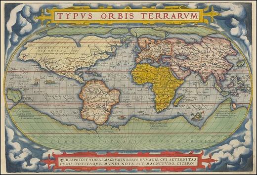
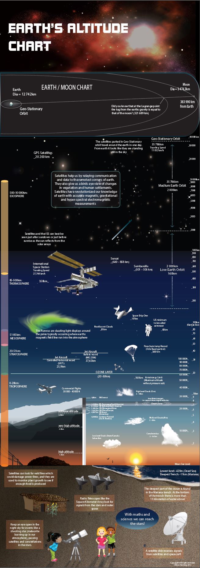
CVersteeg · CC BY-SA 4.0
Altitude is a distance measurement, usually in the vertical or 'up' direction, between a reference datum and a point or object. The exact definition and reference datum varies according to the context, such as aviation, geometry, geographical survey, sport, or atmospheric pressure. Although the term altitude is commonly used to mean the height above sea level of a location, in geography the term elevation is often preferred for this usage. In aviation, altitude is typically measured relative to mean sea level or above ground level to ensure safe navigation and flight operations.
- field
- Aviation, Geography, Atmospheric Science
- known_for
- Vertical distance measurement with multiple definitions (indicated, absolute, true, pressure, density altitude) and its role in aviation safety, high-altitude sports, and atmospheric layering
- types
- Indicated altitude, Absolute altitude, True altitude, Height, Pressure altitude, Density altitude
- atmospheric_layers
- Troposphere, Stratosphere, Mesosphere, Thermosphere, Exosphere
Lore & Background
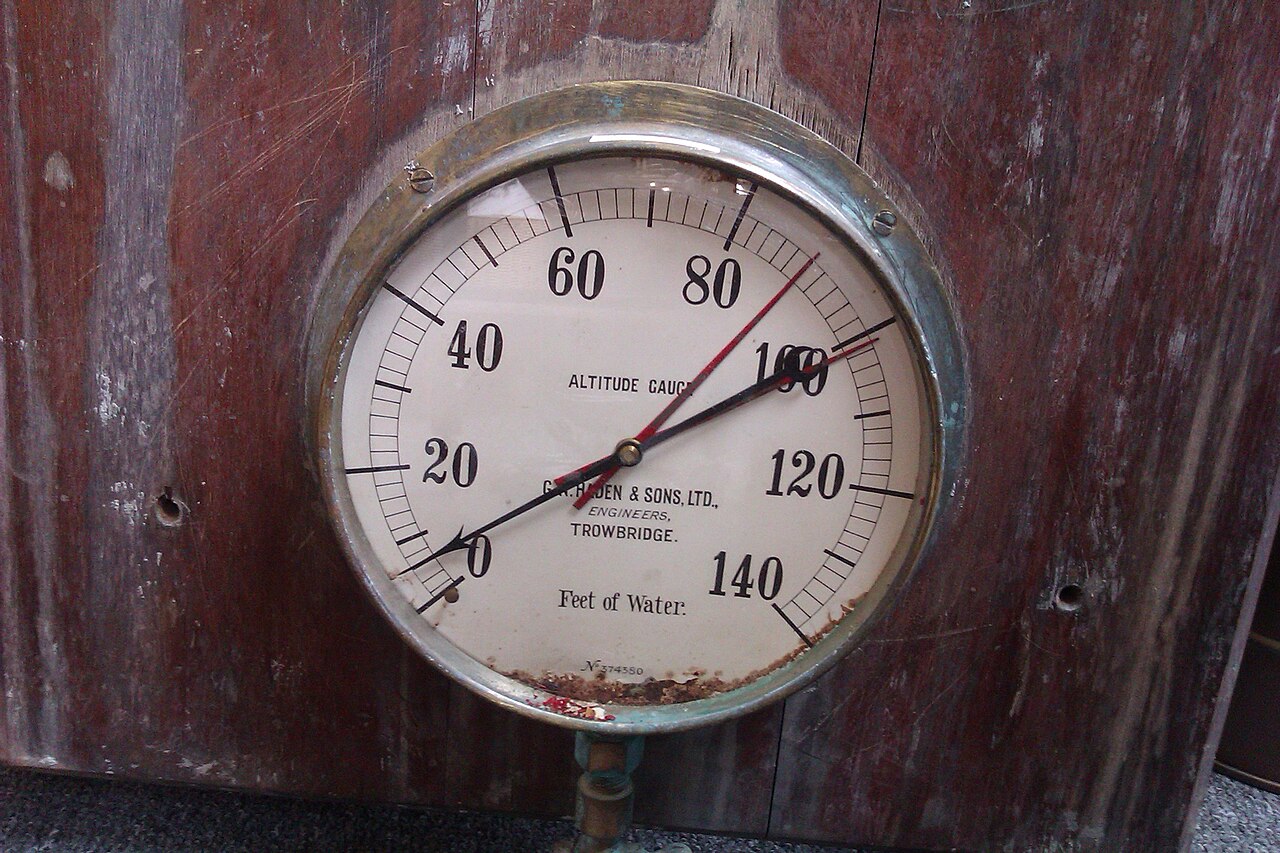
In aviation, altitude has several distinct meanings. Indicated altitude is the reading on the altimeter when set to local barometric pressure at mean sea level. Absolute altitude is the vertical distance above the terrain, measured by radar altimeter. True altitude is the actual elevation above mean sea level, corrected for non-standard temperature and pressure. Height refers to vertical distance above a specified datum, such as an airfield elevation. Pressure altitude is the elevation above a standard datum air-pressure plane, used to indicate flight level. Density altitude is altitude corrected for non-ISA atmospheric conditions, affecting aircraft performance.
Reader's Guide
Altitude is a fundamental concept in multiple fields, with its definition shifting based on context. In aviation, precise altitude types—indicated, absolute, true, height, pressure, and density—are essential for safe navigation, aircraft separation, and performance calculations. Barometric altimeters provide approximate readings useful for standardizing flight paths, while GPS and radio altimeters are critical near the ground. The temperature profile of the troposphere follows an adiabatic lapse rate, averaging 6.49 °C per kilometer in the ISA. Altitude affects human physiology, with permanent residents at higher altitudes showing lower mortality rates and reduced obesity prevalence.
Did You Know?
- In aviation, indicated altitude is the reading on the altimeter when set to local barometric pressure at mean sea level.
Ancient Origins and the Birth of Spatial Measurement
The story of how humanity learned to pin down a location on Earth stretches back to the third century BC, when Eratosthenes of Cyrene composed a work called Geography at the Library of Alexandria. That text has been lost, but a century later Hipparchus of Nicaea refined the approach, deriving latitude from observations of the stars instead of the sun's altitude and tackling longitude through the timing of lunar eclipses rather than rough dead-reckoning. In the first or second century, Marinus of Tyre pushed the method further, compiling a vast gazetteer and a mathematically plotted world map. He chose the Fortunate Isles—likely the Canary or Cape Verde Islands off western Africa—as his prime meridian and measured latitude relative to the island of Rhodes. Ptolemy, writing in the second century, adopted Marinus's framework but shifted the latitude reference to the Equator. After Arabic translations in the ninth century, Al-Khwārizmī corrected errors in the Mediterranean's length, nudging medieval Islamic cartography toward a prime meridian roughly ten degrees east of Ptolemy's. In Europe, Maximus Planudes recovered Ptolemy's text just before 1300, and Jacopo d'Angelo rendered it into Latin in Florence around 1407, reigniting mathematical cartography on the continent.
The Architecture of Latitude and Longitude
Latitude and longitude form a pair that, despite resembling Cartesian coordinates, operates on a fundamentally different principle: the measurements are angular and the surface is curved rather than flat. Latitude can be defined in three distinct ways depending on the coordinate system. In an astronomical system, the reference point on the equatorial plane is found by extending the plumb-bob vertical from the surface. A geodetic system uses the normal vector to the reference ellipsoid, while a geocentric system draws a line to Earth's center. All points sharing the same latitude trace a circle called a parallel. The equator sits at zero degrees and splits the globe into Northern and Southern Hemispheres, while the poles mark ninety degrees. Longitude measures the angular offset east or west from a chosen reference meridian; every meridian is half of a great ellipse converging at both poles. The international prime meridian runs through the Royal Observatory in Greenwich, though bodies such as France's national mapping agency still employ alternative meridians internally. The grid these lines create on a map is called a graticule, and its zero point falls in the Gulf of Guinea roughly six hundred twenty-five kilometres south of Tema, Ghana—a spot playfully dubbed Null Island. Notably, this two-dimensional system says nothing about altitude or depth below the surface.
Geodetic Datums – Anchoring Theory to the Physical World
To translate the elegant geometry of latitude, longitude, and height into measurements that match the real, lumpy Earth, a geodetic datum is essential. A horizontal datum governs latitude and longitude by binding a reference ellipsoid to the planet, while a vertical datum handles elevation and altitude by anchoring a more precise surface called the geoid. Historically, this binding was achieved through networks of surveyed control points—physical monuments set at known locations—whose accuracy was limited to a particular region. Modern datums, by contrast, rely on global satellite-based measurement networks employing techniques such as GNSS, VLBI, SLR, and DORIS, giving them worldwide consistency. Full specifications for these systems are catalogued in standards maintained by the EPSG registry and the ISO 19111 framework. A critical consequence of the datum concept is that two users working with the same datum will always obtain identical coordinates for a given physical point. Yet switch to a different datum and the coordinates for that very same spot can shift by several hundred metres. This discrepancy does not reflect any actual movement of the ground; it is purely a product of the reference frame itself being offset relative to the one used before.
The 1884 Meridian Conference and the Politics of Zero
For centuries, different cultures and cartographers had anchored their longitude measurements to different prime meridians—Marinus and Ptolemy chose the Fortunate Isles, medieval Islamic maps drifted roughly ten degrees east, and European nations each favoured their own observatories. The question of a single global zero line was finally put to a formal vote in 1884, when the United States hosted the International Meridian Conference. Representatives from twenty-five nations gathered, and twenty-two of them agreed to adopt the meridian passing through the Royal Observatory in Greenwich, England, as the universal zero-reference. The Dominican Republic cast the sole vote against the motion, while France and Brazil abstained. France would not follow suit until 1911, when it replaced its long-standing local time determinations by the Paris Observatory with Greenwich Mean Time. Even today, some institutions retain internal use of alternative meridians. The 1884 decision thus represents a rare moment in which a purely technical question—where to draw the zero line—became entangled with national pride, diplomatic negotiation, and the slow, uneven adoption of a shared spatial language.
Gallery
Frequently Asked Questions
What is Altitude in physical geography?
Altitude refers to the vertical distance measured upward from a chosen reference point (a datum) to a given location or object. The specific datum and definition shift depending on the field—aviation, surveying, atmospheric science, or sport—so the same word can carry slightly different meanings in each context.
What are the main types of Altitude?
The concept splits into several variants: indicated, absolute, true, height, pressure altitude, and density altitude. Each one anchors the measurement to a different baseline, such as mean sea level, the local ground, or a standardized atmospheric model.
How does Altitude differ from Elevation?
In everyday speech people often use the two terms interchangeably, but geographers reserve 'elevation' for height above sea level of a fixed surface point. 'Altitude' is the broader, more flexible term that can reference any datum and is especially common in aviation and atmospheric work.
Why is Altitude critical in aviation?
Pilots rely on altitude readings—typically referenced to mean sea level or above-ground level—to maintain safe separation between aircraft and terrain. Without a consistent vertical measurement standard, collision avoidance and controlled descents would be far more dangerous.
More in Physical Geography & Elevation 1-24
Elsewhere in the Physical Geography & Elevation universe
Spotted an error? Know more?
This is a living reference — every entry is fact-audited, and reader corrections feed straight into our audit queue. Suggest an edit · See this site's audit record